Code: TTMADIDI Duration: 14 days
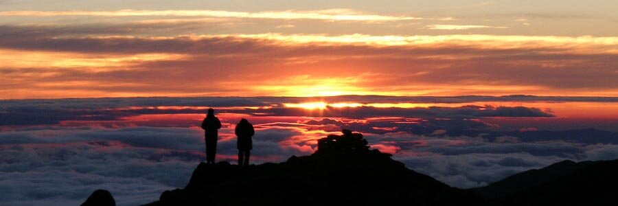
When we were looking for a new trekking destination in Bolivia, we didn’t realize that we probably found the best mountain trek in Bolivia and one of the best in South America.
Apolobamba National Park, Ulla Ulla Vicuña Reserve and Madidi National Park have been engulfed into one huge protected area which covers all the ecological steps in the Andes and the Amazon: from the high glaciated mountains down into the very Amazon rain forest.
As the area is slightly populated, the nature is at its most pristine form. Therefore, chances of spotting wild animals are far more realistic than anywhere in the Andes: Condors, dozens of bird species, lots of Vizcachas (Andean Marmot), and – with some luck - a spectacled bear, coyotes, deer, foxes or occasionally, pumas.
Our route starts in the most remote and isolated mountains to the north of Pelechuco where we cross the "English pass" and then follows the western side of the Apolobamba mountain range. The expedition route ends in Curva; the capital of the Callawayas.
The journey will give us a very deep insight of Bolivia’s culture while you trek in the remote magnificence of the biggest protected area in Bolivia and one of the largest in South America. Along the way, besides visiting several ancient pre-Hispanic ruins, we will meet some of the original ethnic groups, who have been keeping their lifestyles for centuries, away from western civilization: the Aymaras around Titicaca Lake, the Quechuas on the northern Apolobamba range and the Callawayas on its southern end.
Truly, an experience of a lifetime!
Short Itinerary
Day 1. Arrival in La Paz. Transfer to Hotel.
Day 2. Hike on Peñas. Transport to Copacabana. Hotel.
Day 3. Trek to Chincana. Transport to Huatajata. Hotel.
Day 4. Transport to Aguas Blancas. Basic hostel.
Day 5. Trek to Llajta Cuchu. Camp.
Day 6. Trek to Suches. Camp
Day 7. Rest day or Round trip to Chucuyo lagoon. Camp
Day 8. Trek to Kota Piquiña. Camp.
Day 9. Trek to Kellu Pata. Camp.
Day 10. Trek to Puyu Puyu. Camp.
Day 11. Trek to Cañuma. Camp.
Day 12. Trek to Curva. Basic hostel.
Day 13. Transport to La Paz. Hotel.
Day 14. Departure. Transfer to Airport.
Highlights
- Acclimatization sightseeing at Lake Titicaca & surroundings.
- Splendid views of mountain landscape; land of the Kallawayas, famous Andean witch doctors.
- 10 days of trekking (113km total distance).
Services Included
- All transfers IN/OUT to airports.
- Meals mentioned in the itinerary.
- Full land transportation during the trip.
- Hotel accommodation as mentioned in the itinerary.
- Common camping equipment: 3 season tents, dinning and kitchen tents & tableware.
- Bilingual guide during the trip.
- Luggage transportation with porters and/or animals (15 kg/33 lb per person max weight).
- Cook when camping.
- National Park entrance fees.
Services Not Included
- International & local flight tickets & fees.
- Meals & accommodation while in La Paz.
- Personal camping equipment: sleeping bag, mattress, headlamps, and clothing.
- Insurance of any kind.
- Any expense due to a rescue operation (rescuers fee, transportation, or medical cost).
Day to day details
Arriving at the airport in La Paz your breath will be taken away. Not just because of the altitude; the airport is the highest international airport in the world; but also because of the views over the mountains. The crisp clear sky of the highlands give the impression you could touch them. In a normal winter day it is possible to see over a distance of 200Km (120mi). The cold and dry air feels good after so many hours of treated pressurized cabin air.
The drive to the city of La Paz is not less impressive. We will stop at “La Ceja” (literally the eyebrow in Spanish; but also meaning the edge) and have a view on the amazing city with buildings and houses hanging from the steep slopes and filling the whole valley that is surrounded by huge glaciated mountains.
Then we will descend 500m (1640ft) down to our hotel in downtown. Do not get stressed much about the altitude; our program has been designed to get you gradually acclimatized. At the beginning we strongly suggest you to take it very easy, drink plenty of water and eat lightly (get into out Acclimatization page for more information).
You will have the rest of the day free. At early evening we will have a briefing meeting.
Overnight: Hotel Nayra
El Alto: 4,100m (13,450ft)
La Paz: 3,650m (11,972ft)
Driving: 30Min (11km)
None
After breakfast we will take our transport and head north towards Lake Titicaca. Half of the way we will do our first hike in this small rocky range facing Cordillera Real. After the hike we will board our vehicle to get to the shores of the lake where we will stay in one of the best hotels in the area.
Traveling through this land it is easy to understand how important the shores of Lake Titicaca have been in the development of Andean cultures. Surrounded by desert like hills and snowcapped mountains, the lake offered, and still offers, rich lands and a mild climate. On the way to Copacabana, we will be culturally transferred to the past as we go by Aymara villages where Indians have been keeping their lifestyle for centuries.
Overnight: Hotel Rosario del lago
Trailhead: 4,011m (13,156ft)
Peñas: 4,333m (14,212ft)
Lake Titicaca: 3,810m (12,497ft)
Driving: 4-5Hrs (185km)
Walking: 3-4Hrs (4km)
B,L
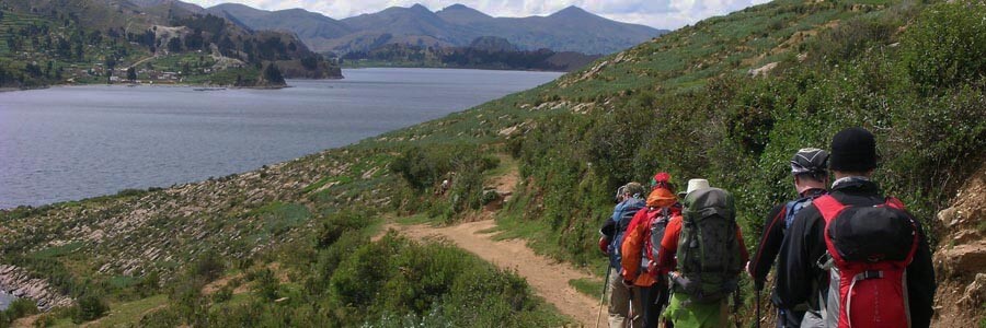
An early start to make a short but pleasant drive along of the shores of Copacabana peninsula towards the village of Yampupata, there we will board the motor boat that will take us to the Island of the Sun. Today we will trek the whole length of the island admiring the Inca terraces, many of which are still used, passing through villages and walking along sandy beaches. Our objective is to reach the north-west end of the island where we can visit a sacred rock, which was worshipped as the birthplace of the first Incas: MancoKapac and Mama Okllo, son and daughter of Viracocha. We will also have time to visit the ruins of Chincana (the labyrinth). After lunch we will take our motor boat back to mainland and then our vehicle towards another Indian Village at the lake shores: Huatajata. The mountains will “grow” in front of us dominating the landscape and the glaciers will get “tanned” by the late afternoon light as we approach to our hotel.
Overnight: Hotel Inca Utama
Island of the sun: 4,065m (13,333ft)
Chincana: 3,830m (12,529ft)
Huatajata: 3,810m (12,497ft)
Walking: 3-4Hrs (11km)
Motor boat: 2-3Hrs (13km)
Driving: 4-5Hrs (100km)
B,L,D
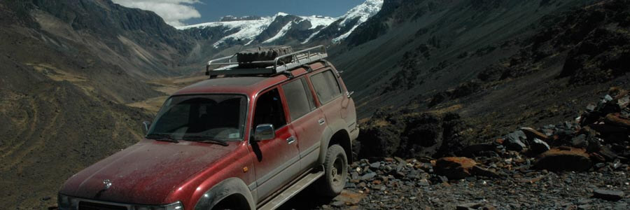
We normally think that driving almost all day long can be really boring, but driving to the valley of Pelechuco does not feel that long. The road follows the eastern shores of Lake Titicaca and afterwards gets into the rolling hills of Muñecas mountain range. As the rocks change colors and the lakes shown their colored waters, the car runs into the Ulla Ulla plateau, the largest Vicuña reserve in Bolivia. Thousands of wild animals run in front of glaciated peaks and colorful lakes. Finally the road passes in between the glaciated mountains and descends to the mining town of Aguas Blancas where we overnight in their lodge. The Lodge has nothing to do with last night’s four-star but is as charming as the town.
Overnight: Basic hostel
Road pass: 4,860m (15,946ft)
Aguas Blancas: 3,967m (13,012ft)
Driving: 8-9Hrs (300km)
B,L,D
An ancient trail, probably thousands of years old, will lead us first downhill along of Pelechuco river towards an archaeological site where the town of Pelechuco was originally founded. Outstanding from the old stone walls and terraces are the unique thumbs of this site. Gradually we will ascend to the top of the scenic ridge from where we can see a great part of the Apolobamba range and the valleys covered with clouds that link the mountains with the Amazon basin. Later we will descend to the other side to the valley of Macara and gradually ascend towards our campsite located at the top end of the valley. We will enjoy great views of the spectacular mountains of Llamaca group. Tonight will be chilly since the glaciers around the campsite cool the air. Our campsite will be located near a place that locals call “Gringo Machai” (the cave of the “gringos”).
Overnight: Camping
Ridge: 4,620m (15,154ft)
Llajta Cuchu: 4,650m (15,257ft)
Walking: 7-8Hrs (15km)
B,L,D
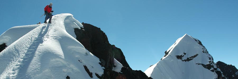
We are getting into the very high lands of the Apolobamba and from our campsite glaciers and the peaks will seem so close that one thinks about touching them. Do not be fooled, the air is so clean and thin that everything looks closer than it is. Today will be our “Test of fire” since; we have to cross the highest mountain pass a high pass with a glacier. First we will ascend over old moraines and through rocky galleys to the Chucuyo pass (also known as English pass). We have to cross a glacier that miners of “Flor de Nevada” gold mine used to traverse regularly using rubber boots!. Unfortunately, and due to the severe glacier receding that is happening in the whole Andes, this not an “easy” walk anymore. Although there is not technical climb involved, the glacier itself – especially the edges – are very icy and we will take the precaution of using crampons. Once on the other side will hike, following a secondary road, to our campsite located much lower into the valley of Lake Suches.
Overnight: Camping
English Pass: 5,250m (17,225ft)
Lake Suches: 4,700m (15,421ft)
Walking: 7-8Hrs (13km)
B,L,D
After two long days in a row, we will spend a well-deserved rest day at this campsite. For those who do not need to rest, our guide can take you for a round trip towards Chucuyo lagoon from where you can have a splendid view of Chaupi Orko mountain.
Overnight: Camping
Lake Suches: 4,700m (15,421ft)
Optional walking: 4-5Hrs (9km)
B,L,D
The main characteristic of the western side of the range is that there is less vegetation; we will see more lakes and snow on the western slopes of the mountains since we will be hiking much higher and much closer to the glaciers. Since we will be hiking close to the mountains that face the Ulla Ulla plains, the trails are not as big and well-designed than those on the eastern side but the high mountain landscape is enough reward. Today, we will start our trek through the Bolivia’s biggest Vicuña reserve. After crossing a mountain pass, we will descent to the main road that leads us to Pelechuco several days ago. Our campsite will be located near the village of Kota Piquiña, the main economic activity in the area is Alpaca farming, animal that benefit local communities with the meat (delicious, low in fat and with high content of protein), leather and mainly wool. Certainly – while resting at the campsite - we will receive the visit of artisans who will try to sell us alpaca garments they knit and weave.
Overnight: Camping
Mnt Pass: 5,100m (16,733ft)
Kota Piquiña: 4,600m (15,088ft)
Walking: 6-7Hrs (15km)
B,L,D
Today as it usual we will cross other mountain pass with its own group of peaks; competing each other in wilderness and beauty. After getting deep into a beautiful valley we will climb to a mountain pass and descend to the valley of an amazing number of colorful lakes that certainly will became the main attraction for the day. We usually camp close to an Alpaca farm near one of the numerous lagoons in the valley.
Overnight: Camping
Mnt Pass: 5,210m (17,094ft)
Nube: 4,650m (15,257ft)
Walking: 8-9Hrs (18km)
B,L,D
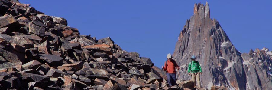
Another day between the mountains and the highlands, after contouring a beautiful small lake dotted with numerous birds, we will cross to the other side of the valley and start ascending towards a rocky peak topping the ridge that divides two valleys. The views from this summit are just breathtaking, you can almost see the whole Apolobamba range like if you were on a plane. The bottom of the valleys – as usual – will be all dotted with hundreds of llamas, alpacas and Vicuñas herding on the river banks while rock and ice are the main elements when we look up to the mountains. We will camp in a flat grassy field for tonight.
Overnight: Camping
Trekking peak: 5,087m (16,685ft)
Puyu Puyu: 4,750m (15,585ft)
Walking: 6-7Hrs (10km)
B,L,D
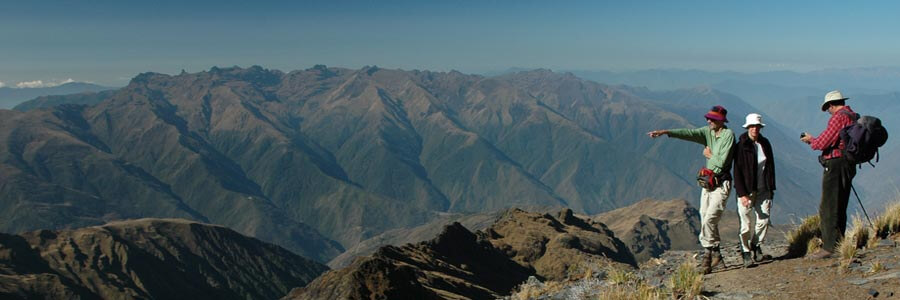
After a long up and down traverse following boggy lands, grassy ridges and rocky terrain, we will climb a sandy peak called “Cerro Morado” (purple hill) because of its peculiar color due to its content of iron. The reward is the best 360 degree view of the trek including: the whole Apolobamba mountain range, the Ulla Ulla plains, Lake Titicaca on the horizon, the deep valleys of Muñecas mountain range, and – to the south – the Illampu-Janko Uma massif of Cordillera Real. After enjoying the astonishing landscape, we have to descend over loose terrain to the other side into Cañuma (Dirty Water) valley.
Overnight: Camping
Cerro Morado: 5,136m (16,846ft)
Chojña Kota: 4,519 m (14,822 ft)
Walking: 5-6Hrs (10km)
B,L,D
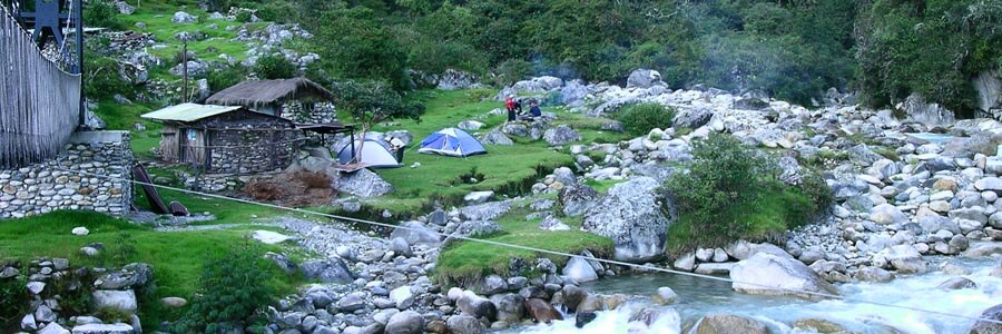
Today is quite a long journey since we do not only have to cross two mountain passes, but also cover a long distance to arrive to Curva town. Both mountain passes are not as high as the last’s days. We will keep walking along the lower slopes of Akamani, the sacred mountain of the Callawayas. After the second pass, we will descend to Canisaya valley; the head valley of Curva town; land of the Callawaya Indians. They are famous in the whole Andes Range because they are healers and Witch doctors. Their knowledge has been transmitted from father to son for centuries. It is said that they were the official doctors of the Inca Aristocracy. Our route will gradually leave the highlands to get us in their land and meet people living the same way as five hundred years ago. Depending of the distance we can make, we will either hike all the way to Curva or be picked-up by our car on Canisaya village.
Overnight: Basic hostel
Ulla Kaya pass: 4,910m (16,110ft)
Caballuni river: 4,100m (13,448ft)
Canisaya pass: 4,400m (14,436ft)
Curva: 3,600m (11,812ft)
Walking: 8-9Hrs (18km)
Driving: 30-45Min (6km)
B,L,D
We will take the same road back to La Paz. On the way back we will make a short visit to the Callawaya capital: Charazani. Then the road will lead us to the Altiplano and Lake Titicaca towards La Paz city.
Overnight: Hotel Nayra
Road Paz: 4,800m (15,744ft)
La Paz: 3,650m (11,972ft)
Driving: 8-9Hrs (280km)
B,L
Transfer to airport.
Overnight: None
El Alto: 4,100m (13,450ft)
Driving: 30Min (11km)
None